Outdooractive. Hike and Ride
Contains adsIn-app purchases
4.2star
63.4K reviews
1M+
Downloads

Rated for 3+
info


About this app
Confidently explore the great outdoors with Outdooractive - Hike and Ride: The most reliable outdoor navigation app, as trusted by thousands of trail wardens, mountain guides and outdoor industry professionals worldwide.
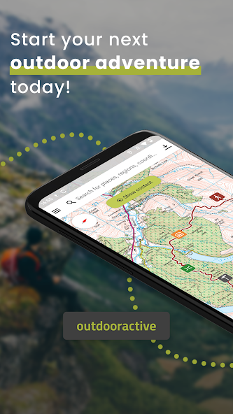
The Outdooractive - Hike and Ride app helps you find officially approved routes near you and around the world, with suggestions for dozens of sports including: hiking paths, trekking trails, mountain biking routes, trail running paths, ski touring routes and more. Or plan your own routes using the deepest catalog of official maps to take adventures into your own hands.
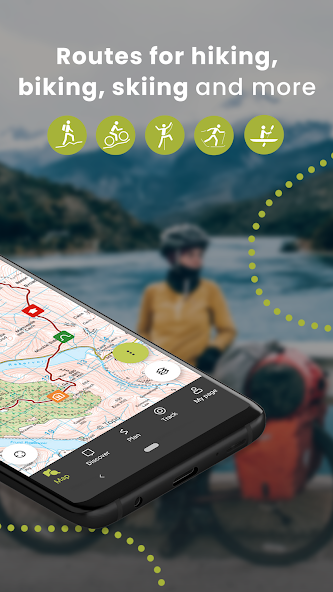
● Find routes you can rely on: Browse thousands of officially-approved routes near you and across the world, including routes for hiking, road cycling, bike touring, ski touring, gravel riding, trail running, horseback riding, mountaineering and more.
● Plan your own routes with tools trusted by professionals: Easily plot your own outdoor routes in the route planner in just a few taps, and see all need to know distance, elevation and terrain info.
● Save everything offline: Save individual plans or entire areas offline for reliable navigation when you don't have a phone signal.
● Navigate with the most reliable maps on the planet: Browse the deepest collection of different map types to track or plan your adventures with confidence. Simply switch between different layers to get a clearer picture of the terrain you're planning to visit, and get the most reliable understanding of conditions on the ground. Outdooractive's map catalog currently includes:
- Official topo maps in 25 countries, including:
• Ordnance Survey (Landranger & Explorer) in the United Kingdom
• New Zealand Land Information in NZ
• USGS in the USA
• BKG in Germany
• BEV in Austria
• Swisstopo in Switzerland
• IGN in France
• CNIG in Spain
• PDOK in the Netherlands
• Kartverket in Norway
• Kortforsyningen in Denmark
• Lantmäteriet in Sweden
• Finland National Land Survey in Finland
• GSI in Japan
• Harvey Maps in the UK's most mountainous areas
- The official Alpine Club maps for climbing in the Alps
- The specially-designed Outdooractive map across France, Germany, Austria and Switzerland.
● Share your live location with family and friends: Give yourself and your loved ones complete peace of mind when you're out in the great outdoors thanks to BuddyBeacon.
● Join a global community of outdoor tourists and adventurers: Share your activities with the community, join challenges to stay motivated, and get inspired by officially-approved content from our thousands of industry partners.
● Smartwatches with WEAR OS from Google: With a glance at your Smartwatch, you get information about your GPS position on the map. You can record tracks, get tracking data and navigate along routes.
FAQs:
Can Outdooractive find walking trails near me?
Outdooractive helps you find walking, hiking, cycling and many more types of trails both in your area, and around the world.
How can I find hiking trails near me?:
Using Outdooractive, you're able to find hiking trails in your local area by opening our app and browsing the map. You'll be able to see hiking trails with a range of distances, difficulties and distance from your location.
How do I know which hiking trails close to me are best to follow?:
Using Outdooractive's multiple map layers, you're able to view official information from multiple sources, to inform you about trail conditions, rules, restrictions and what to expect on your hike. Experts will share information on each route on its difficulty, required experience level and more!
Can I download offline maps to navigate nature walks and areas to hike near me?:
Outdooractive allows you to download maps and routes to your device before heading out, to help you navigate those areas where signal isn't guaranteed — allowing you to reliably navigate the outdoors.
The Outdooractive - Hike and Ride app helps you find officially approved routes near you and around the world, with suggestions for dozens of sports including: hiking paths, trekking trails, mountain biking routes, trail running paths, ski touring routes and more. Or plan your own routes using the deepest catalog of official maps to take adventures into your own hands.
● Find routes you can rely on: Browse thousands of officially-approved routes near you and across the world, including routes for hiking, road cycling, bike touring, ski touring, gravel riding, trail running, horseback riding, mountaineering and more.
● Plan your own routes with tools trusted by professionals: Easily plot your own outdoor routes in the route planner in just a few taps, and see all need to know distance, elevation and terrain info.
● Save everything offline: Save individual plans or entire areas offline for reliable navigation when you don't have a phone signal.
● Navigate with the most reliable maps on the planet: Browse the deepest collection of different map types to track or plan your adventures with confidence. Simply switch between different layers to get a clearer picture of the terrain you're planning to visit, and get the most reliable understanding of conditions on the ground. Outdooractive's map catalog currently includes:
- Official topo maps in 25 countries, including:
• Ordnance Survey (Landranger & Explorer) in the United Kingdom
• New Zealand Land Information in NZ
• USGS in the USA
• BKG in Germany
• BEV in Austria
• Swisstopo in Switzerland
• IGN in France
• CNIG in Spain
• PDOK in the Netherlands
• Kartverket in Norway
• Kortforsyningen in Denmark
• Lantmäteriet in Sweden
• Finland National Land Survey in Finland
• GSI in Japan
• Harvey Maps in the UK's most mountainous areas
- The official Alpine Club maps for climbing in the Alps
- The specially-designed Outdooractive map across France, Germany, Austria and Switzerland.
● Share your live location with family and friends: Give yourself and your loved ones complete peace of mind when you're out in the great outdoors thanks to BuddyBeacon.
● Join a global community of outdoor tourists and adventurers: Share your activities with the community, join challenges to stay motivated, and get inspired by officially-approved content from our thousands of industry partners.
● Smartwatches with WEAR OS from Google: With a glance at your Smartwatch, you get information about your GPS position on the map. You can record tracks, get tracking data and navigate along routes.
FAQs:
Can Outdooractive find walking trails near me?
Outdooractive helps you find walking, hiking, cycling and many more types of trails both in your area, and around the world.
How can I find hiking trails near me?:
Using Outdooractive, you're able to find hiking trails in your local area by opening our app and browsing the map. You'll be able to see hiking trails with a range of distances, difficulties and distance from your location.
How do I know which hiking trails close to me are best to follow?:
Using Outdooractive's multiple map layers, you're able to view official information from multiple sources, to inform you about trail conditions, rules, restrictions and what to expect on your hike. Experts will share information on each route on its difficulty, required experience level and more!
Can I download offline maps to navigate nature walks and areas to hike near me?:
Outdooractive allows you to download maps and routes to your device before heading out, to help you navigate those areas where signal isn't guaranteed — allowing you to reliably navigate the outdoors.
Updated on
Safety starts with understanding how developers collect and share your data. Data privacy and security practices may vary based on your use, region, and age. The developer provided this information and may update it over time.


Ratings and reviews
4.1
60.9K reviews

Nick Miller
- Flag inappropriate
- Show review history
May 13, 2025
initial impressions good with easy downloading of areas, snappy loading of maps and zooming BUT overemphasis on social and route finding functions so there's limited phone screen left to actually view the map! No option to fix scale so that zooming out for route planning doesn't change to road atlas or other map... edit - prompt customer service with simple (obvious) touch on map to go full screen. They will consider Scale Lock
2 people found this review helpful

Aliaksandr Yermak
- Flag inappropriate
June 1, 2025
It's pretty annoying. all the time, a lot of notifications and suggestions. it somehow thinks I want to add some photos, but I do not! it can't remember the last activity type - all the time, I need to choose it from the very beginning. Actually, it tries to make me save my route, but I don't want to. I need just navigation and nothing more. all the time, I just struggle with the rest of the features. don't think I by it.

m b
- Flag inappropriate
- Show review history
May 29, 2025
Originally, like many Viewranger users being transferred here, I was unimpressed, especially by the loss of my purchased map tiles during the transfer. However, we were offered free Pro status to ease transfer which sounded good at first. That ended and I lost everything, but an appeal to Support fixed the issue to protect my investment with enhanced value. Very Satisfied.
10 people found this review helpful
Outdooractive AG
July 5, 2022
Hi M B, everyone who owned maps in ViewRanger gets at least the same maps permanently in Outdooractive. On the website, click your name top right. If there's a green box about legacy maps, agree that. In the app use My Page, Sync. You'll see an extra OS item (or others) on the map layers panel. For more help, please email service@outdooractive.com.
What’s new
In this version we fixed some bugs and made some performance improvements.
Do you have any questions or suggestions? Shoot us an email to service@outdooractive.com
Your Outdooractive Team
Do you have any questions or suggestions? Shoot us an email to service@outdooractive.com
Your Outdooractive Team
App support
About the developer
Outdooractive AG
technik@outdooractive.com
Missener Str. 18
87509 Immenstadt i. Allgäu
Germany
+49 8323 8006690