My Track
Contains adsIn-app purchases
4.0star
13.8K reviews
1M+
Downloads

Rated for 3+
info


About this app
My Track is a small and powerful application to keep track of your route while you go around. The quite complex functionality hides behind a very clear user interface which is easy to understand.
My Track can be very useful for all of your outdoor activities like hiking, bicycle and motorcycle touring, boating, skiing, climbing or sheer driving fun, it can also be used for business.
Have a look at all of these fancy features:
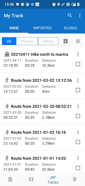
1. Record a route
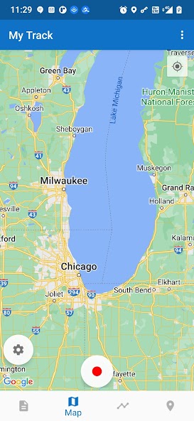
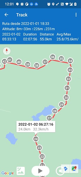
1.1 show current location on Google Map, along with time, duration and distance. even with latitude and longitude.
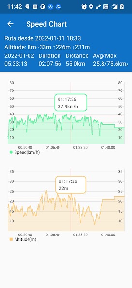
1.2 dynamic chart about speed and altitude.
1.3 route recording, pausing, resuming, saving and listing.
1.4 photos joining with a route automatically, whatever app you use to take photos.
1.5 voice report at predefined frequency of time or distance when recording
1.6 export routes to GPX/KML/KMZ files, or import from your phone or Google Drive.
1.7 sync and restore from Google Drive.
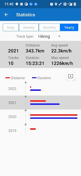
1.8 do stats.
1.9 show multi routes on the map.
1.10 print a route with the map.
2. Share a route
2.1 create a group and invite friends to join this group, you and your friends can share routes in this group.
2.2 share a route globally in this app.
2.3 share a route via web url to social medias, like WhatsApp, FaceBook, Gmail, etc.
2.4 select photos to share with a route.
3. Follow a route
3.1 follow your own route.
3.2 follow others’ shared route.
3.3 follow planned route.
3.4 fly your imagination: share a route in a group, friends in this group can follow this route.
4. Plan a route
4.1 plan a route(driving, bicycling and walking) among multi markers, the planed route can be followed on the map.
5. Markers
5.1 tap on the map to insert a marker, move the map to put the marker on proper position.
5.2 select markers to show on the map.
5.3 markers can be remembered to show next time when you open the app.
5.4 markers can be shared or exported within a route.
5.5 export markers to a KML file.
6. More
6.1 Live broadcast your locations to friends.
6.2 download offline map.
6.3 add map layer, and auto load this layer when the app starts.
6.4 click the map to measure distance, measure area, or to connect points to design a route line.
The app needs such permissions:
1. Storage permission for route saving.
2. Photo permission for joining photos with a route.
3. Location permission for route recording.
4. Internet permission for route sharing.
Attention:
1. Google Play and Google Maps should be installed first.
2. All basic features are free forever.
3. After 15 days you may see ads, you can pay to remove ads forever.
4. After 60 days you may subscribe to advanced features, or watch a video to get one time's feature permission.
My Track can be very useful for all of your outdoor activities like hiking, bicycle and motorcycle touring, boating, skiing, climbing or sheer driving fun, it can also be used for business.
Have a look at all of these fancy features:
1. Record a route
1.1 show current location on Google Map, along with time, duration and distance. even with latitude and longitude.
1.2 dynamic chart about speed and altitude.
1.3 route recording, pausing, resuming, saving and listing.
1.4 photos joining with a route automatically, whatever app you use to take photos.
1.5 voice report at predefined frequency of time or distance when recording
1.6 export routes to GPX/KML/KMZ files, or import from your phone or Google Drive.
1.7 sync and restore from Google Drive.
1.8 do stats.
1.9 show multi routes on the map.
1.10 print a route with the map.
2. Share a route
2.1 create a group and invite friends to join this group, you and your friends can share routes in this group.
2.2 share a route globally in this app.
2.3 share a route via web url to social medias, like WhatsApp, FaceBook, Gmail, etc.
2.4 select photos to share with a route.
3. Follow a route
3.1 follow your own route.
3.2 follow others’ shared route.
3.3 follow planned route.
3.4 fly your imagination: share a route in a group, friends in this group can follow this route.
4. Plan a route
4.1 plan a route(driving, bicycling and walking) among multi markers, the planed route can be followed on the map.
5. Markers
5.1 tap on the map to insert a marker, move the map to put the marker on proper position.
5.2 select markers to show on the map.
5.3 markers can be remembered to show next time when you open the app.
5.4 markers can be shared or exported within a route.
5.5 export markers to a KML file.
6. More
6.1 Live broadcast your locations to friends.
6.2 download offline map.
6.3 add map layer, and auto load this layer when the app starts.
6.4 click the map to measure distance, measure area, or to connect points to design a route line.
The app needs such permissions:
1. Storage permission for route saving.
2. Photo permission for joining photos with a route.
3. Location permission for route recording.
4. Internet permission for route sharing.
Attention:
1. Google Play and Google Maps should be installed first.
2. All basic features are free forever.
3. After 15 days you may see ads, you can pay to remove ads forever.
4. After 60 days you may subscribe to advanced features, or watch a video to get one time's feature permission.
Updated on
Safety starts with understanding how developers collect and share your data. Data privacy and security practices may vary based on your use, region, and age. The developer provided this information and may update it over time.


Ratings and reviews
4.0
13.4K reviews

Jeremy Davis
- Flag inappropriate
- Show review history
June 3, 2025
I've had this app for years and am using it again for bike riding. My gripe is that now it requires a subscription for things that used to be free. Such as mph or elevation during my ride(no graphs available without subscription). It posts total elevation or mph average but I cannot see it throughout ride. edit after response: no i will no longer use this app due to it now charging for graphs. I have switched apps due to me liking the charts to identify my speed with elevation.
Daniel Qin
June 4, 2025
Hi Jeremy, thanks for keeping using this app, actually I forget to put subscription on the detail tab's speed and altitude chart, this of course is one of advanced features. The basic features are route recording, route listing and route viewing, these are mostly used and free forever. More : there is no plan to change the current setting.

Roger B.
- Flag inappropriate
May 18, 2025
I love this app and have been using it for many years. I deducted one star because of the details page lists altitude in meters and speed (average & max) in km/h. Also, the distance meter on the map list distances in meters. I've tried to switch it to mi/hr and feet to no avail in the settings. All of the other readings are correct in mi/hr and feet. If this was corrected, I would definitely rate this five stars!
1 person found this review helpful
Daniel Qin
May 22, 2025
Hi Roger, Thanks very much for your feedback and your appreciation of this app, I will check this issue and correct it asap. May 23: would you like to upgrade to the latest release V8.1.2 which has fixed the bug?

Alfred Diebel
- Flag inappropriate
May 11, 2025
First issue: I experience recurring doubling of my time during usage, just as my phone awakens from a dark screen power saving mode. Second issue: a recent mapping update has resulted in grossly inaccurate tracking, having me zig zagging multiple times, by fifty to one hundred yards in the span of 3-5 seconds. I don't have wings to make this possible. I have reinstalled multiple times; I am ready to uninstall permanently.
1 person found this review helpful
Daniel Qin
May 11, 2025
Hi, Alfred, welcome your feedback. 1. do you mean a route's duration doubled? this should not happen, pls send me screenshots and details about this issue to track. 2. this app can get accurate locations when you are below open sky and not blocked by metal, not locate your device when in a building or in a car. Pls read this app's help.
What’s new
V8.1.2: Some minor improvements to altitude unit, button background color and table width, etc.
App support
About the developer
Qin ZhiJian
qinzjy@gmail.com
RuiJin Two Road
黄浦区, 上海市
China
200120
undefined